


Pont de la liane

christian19
User
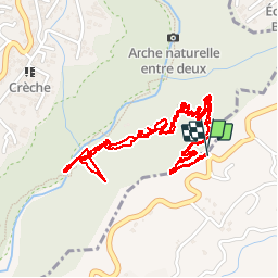

Length
4.7 km

Max alt
534 m

Uphill gradient
405 m
Km-Effort
10.1 km

Min alt
243 m

Downhill gradient
403 m
Boucle
Yes
Creation date :
2016-12-15 00:00:00.0
Updated on :
2016-12-15 00:00:00.0
2h01
Difficulty : Medium

FREE GPS app for hiking
 SityTrail
IGN / Geographical institutes
SityTrail Plus
The world is yours!
About
Trail Walking of 4.7 km to be discovered at Réunion, Unknown, Le Tampon. This trail is proposed by christian19.
Description
La reunion
Positioning
Country:
France
Region :
Réunion
Department/Province :
Unknown
Municipality :
Le Tampon
Location:
Unknown
Start:(Dec)
Start:(UTM)
343110 ; 7649601 (40K) S.
Comments